Long Distance ⬥ Sunday 20th April 2025
Long ⬥ Sunday 20th April
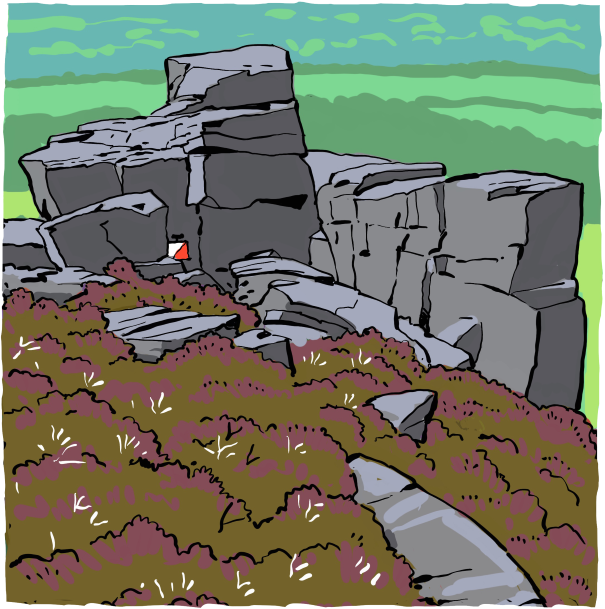
Wharncliffe
Having played host to several British Championships and other major events over the years - including the JK Long back in 1978 - Wharncliffe has proven itself as a rock-hard area, ideal for this year's JK Long.
The boulders strewn on the slopes beneath Wharncliffe's gritstone edges and the areas of intricately contoured former mine workings both demand careful fine navigation. Atop the crags is an expanse of open moorland, and further east the area also includes Wheata Woods with its abundance of thickets, completing Wharncliffe's mosaic of different terrains.
I always felt like orienteering on Wharncliffe was a true test of how good an all-round orienteer you are, as it tests every technical and physical skill and nothing comes easily. I kept coming back for more training here when I lived in Sheffield, hoping that perhaps next time I would finally conquer it.
Matt Crane
Location
Less than 10 km northwest of Sheffield City Centre, Wharncliffe spans the east side of the River Don's valley between Oughtibridge and Deepcar.
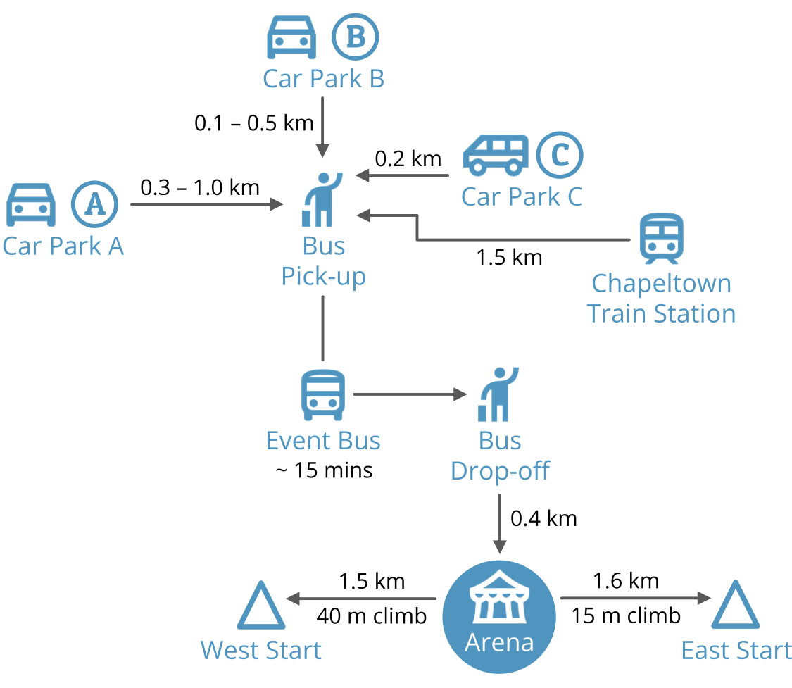
Parking will be in the same location as Day 2, on hard standing in the Winston and Thorncliffe Business Parks. Competitors will then be bussed a short distance to the Arena which is on the SE side of the area, with buses leaving every 10 mins.
Chapeltown is just 12 mins from Sheffield by train, and it is a 1.5 km walk from the train station to where the event buses will be departing from. Alternatively, a variety of public bus services are available, but these will require walking approximately 2.5 km to the Arena from either Grenoside or Burncross.
Travel
Select a button to view travel directions
Please consider using public transport to get to the event parking area, and then catching the Event Bus to the Arena from there. Trains and buses are good to Chapeltown.
The nearest train station is at Chapeltown and trains run regularly from Sheffield, Barnsley and Leeds. From Chapeltown railway station it is about 1.5km to our buses on Thorncliffe Road.
Either cycle direct to the Arena at SK 321958 (see this Suggested Route planned by local orienteers), or cycle to the Car Parks and then catch the Event Bus (no cycles on buses).
All 3 parking areas are spaces around business parks, all accessed via Thorncliffe Road:
Google MapsApple MapsWazeSK352975magical.binder.fillings
If travelling from the south on the M1, leave at junction 35A. At the roundabout turn left into Thorncliffe Road where the speed limit becomes 30 mph.
If travelling from the north on the M1, leave at junction 36. Drive west along the A61 and then at the roundabout turn left along the A616. At the next roundabout turn right into Thorncliffe Road with the 30 mph speed limit. Please note that it is not possible to leave or join the M1 at junction 35A if travelling from or to the north.
Please share transport as much as possible. This is for environmental reasons and because of pressure on our car parking spaces.
Main toilets will be at the Arena. It would be advisable to call at toilets on the way to the parking areas, for example Woolley or the new Rotherham services at J33 on the M1.
Car Parking
There will be 3 car parking areas and you must choose the one you intend to use when you enter. The same choice must be used for Days 2 and 3. The default choice will be Car Park A.
Please drive slowly when you get into the car parks and follow the instructions of marshals. Be aware that there will be many walkers using the same roads as cars.
Car Park A (off Newton Chambers Road)
Google MapsApple MapsWazeSK352973cropping.routine.glitter
Turn left at the roundabout after 800m along Thorncliffe Road and then turn right with care after 100m onto Newton Chambers Road. This car parking will be used by most competitors.
Car Park B (off Churchill Way)
Google MapsApple MapsWazeSK352975earlobe.surprised.bathtubs
Turn right with great care after 650m along Thorncliffe Road. The walk to the bus stop will be between 100m and 400m.
Car Park C (Rotunda Area)
Google MapsApple MapsWazeSK351974fatigued.sharpness.places
Turn right at the roundabout after 800m along Thorncliffe Road. This car park is to be used by all campervans and minibuses. The walk to the bus stop is about 150m.
Buses to the Arena
Buses will leave to the Arena from 8:15, approximately every 6 minutes. The journey will take 15 minutes, and the same time back. The last bus leaves the Arena at 4:30. Dogs are allowed on the buses.
It is then a 400m walk to the Arena from the bus drop-off. The very oldest competitors (M80+ and W75+) have the option of getting off 'ready to run' before the main drop-off, from which point it is a 400m walk to the East start. This would, however, mean that any belongings would need to be left on the bus for someone else to take to the Arena.
Event Schedule
| 08:00 | Car parks open |
| 08:15 | First bus to Arena |
| 08:30 | Arena facilities open |
| 10:00 | First start |
| 14:00 | Last start |
| ~15:30 | Prizegiving & WRE Flower Ceremony |
| 16:00 | Courses close |
| 16:30 | Last bus leaves Arena |
| 16:30 | Arena facilities close |
Day Sponsors


Arena
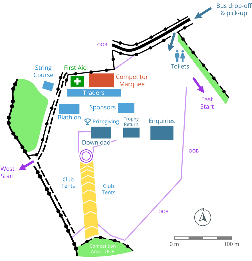
Toilets will be situated near to the Arena.
There will also be one near the East start and three at the West start, one of which is specifically for Elites and Helpers.
Starts
There are two Starts, both approximately 25 minutes walk for an average M/W65 in opposite directions from the Arena.
| Start | Courses | Route | Details |
|---|---|---|---|
| West Start | 1 to 15, 22 to 23 | 1.5km, 40m climb | On exit from the Arena a high wooden style has to be used to get over a 1.5m wall. Please use carefully. The route onto the Chase has a short section of path, and then continues over tussocky grass and broken ground. |
| East Start | 16 to 21, 24 to 26 | 1.6km, 15m climb | The route to the East Start follows footpaths through fields and woodland |
Finish
This will be in the Arena and is the same for all courses. Courses will close at 16:00.
Map
Wharncliffe was last used for a National event in 2022. Courses from this event can be seen on the SYO Routegadget.
The map is to ISOM 2017-2 IOF Specification, unless otherwise stated. Map scale 1:7,500 for Courses 16 to 21 & 24 to 26, 1:10,000 for Courses 7, 9 to 15, 22 & 23, and 1:15,000 for Courses 1 to 6 & 8. Contour interval 5m. Survey and cartography by Dave Peel (Peel Land Surveys) and Ian Cooper (SYO) for JK25.
Terrain Notes
Wharncliffe is an outstanding and formidable area for orienteering. It includes a wide range of terrain types, including a forested plateau, an open moorland and a rocky escarpment cratered with mine workings and capped by a gritstone edge, the magnificent Wharncliffe Crags.
The East Start will be in Wheata Woods. The area won't be as physical as Wharncliffe, but will still be a good challenge, and is more suitable for older and younger competitors. Wheata has an abundance of thickets. The area is well used by walkers and bikers and its path network provides plenty of opportunities for complex route choice.
Wharncliffe has hosted the British Orienteering Championships and other major events and will provide a fitting venue for a challenging but memorable JK Long.
Provisional Course Details
| Course | Classes | Start | Distance (km) | Climb (m) | Controls | Map Scale | Tech Diff |
|---|---|---|---|---|---|---|---|
| 1 | M21E1 | West | 14.1 | 400 | 33 | 1:15,000 | 5 |
| 2 | M21E2 | West | 13.8 | 420 | 33 | 1:15,000 | 5 |
| 3 | W21E1 | West | 11.3 | 380 | 27 | 1:15,000 | 5 |
| 4 | M21L W21E2 | West | 11.9 | 350 | 29 | 1:15,000 | 5 |
| 5 | M18E M20E | West | 9.8 | 285 | 27 | 1:15,000 | 5 |
| 6 | M35L M40L W21L | West | 9.8 | 265 | 27 | 1:15,000 | 5 |
| 7 | M45L M50L | West | 8.3 | 220 | 23 | 1:10,000 | 5 |
| 8 | W18E W20E | West | 7.4 | 190 | 21 | 1:15,000 | 5 |
| 9 | M55L W35L W40L | West | 7.8 | 205 | 20 | 1:10,000 | 5 |
| 10 | M60L M20L M21S | West | 7.5 | 225 | 20 | 1:10,000 | 5 |
| 11 | M16A M18L M35S M40S W45L | West | 6.8 | 220 | 21 | 1:10,000 | 5 |
| 12 | W50L | West | 5.9 | 160 | 16 | 1:10,000 | 5 |
| 13 | M45S M50S W55L W21S | West | 5.8 | 165 | 17 | 1:10,000 | 5 |
| 14 | W60L W20L | West | 5.5 | 135 | 18 | 1:10,000 | 5 |
| 15 | M55S M60S M21V W16A W18L W35S W40S | West | 5.4 | 145 | 18 | 1:10,000 | 5 |
| 16 | M65L | East | 6.4 | 170 | 18 | 1:7,500 | 5 |
| 17 | M70L | East | 5.8 | 150 | 15 | 1:7,500 | 5 |
| 18 | M75L M18S M20S W65L W45S W50S | East | 4.7 | 135 | 14 | 1:7,500 | 5 |
| 19 | M80L M65S M70S W70L W20S W55S W60S W21V | East | 4 | 105 | 11 | 1:7,500 | 5 |
| 20 | M85 M75S M80S W75L W80L W18S W65S W70S | East | 3 | 90 | 9 | 1:7,500 | 5 |
| 21 | M90 M95 W85 W90 W95 W75S W80S | East | 1.9 | 55 | 7 | 1:7,500 | 5 |
| 22 | M14A M16B | West | 4.4 | 105 | 14 | 1:10,000 | 4 |
| 23 | W14A W16B Light Green | West | 3.6 | 85 | 11 | 1:10,000 | 4 |
| 24 | M12A M14B W12A W14B Orange | East | 3.1 | 60 | 10 | 1:7,500 | 3 |
| 25 | M10A M12B W10A W12B Yellow | East | 2.7 | 60 | 11 | 1:7,500 | 2 |
| 26 | M10B W10B White | East | 2.5 | 50 | 14 | 1:7,500 | 1 |
Drinks Point
As required by WRE rules, water will be provided for those on courses 1-5. Many other courses will pass the drinks point. It can be used if really needed. There will be no drinks provided at the Starts. Competitors may bring a plastic bottle to the start to be crushed and placed in rubbish bags for disposal.
Safety Directions
Generally, head East until hitting Woodhead Road, then follow back to the Arena. All competitors must report to the Finish.
Safety
The area is heavily used by the public for dog walking, running, horse riding, and especially mountain biking. Courses have been planned to avoid the main mountain bike tracks, but still be aware that you may cross these tracks, and that bikes may be going fast.
There are the usual hazards with steep and narrow muddy footpaths, rough vegetation, tree roots etc. Please take care.
Prizegiving
The overall JK Prizegiving (Middle and Long combined) and WRE Flower Ceremony will be held at about 15:30, or as soon as possible after this.
Acknowledgements
Our thanks to Forestry England, and the landowners Andrew Hardman and Peaty’s Products.

Officials
Planners - Charlie Adams & Oli Johnson (SYO)
Controller - Andy Yeates (WCH)
Assistant Controller - Jonathan Emberton (EPOC)
Mapper - Dave Peel (Peel Land Surveys)
Organiser - Paul Bradbury (SYO) ![]()
Assistant Organiser - Steve Dempsey (SYO)
IOF Adviser - Steve McKinley (SN)